Tuesday, September 29, 2009

The Lurid Details


2009-08-25: For those who are curious as to what exactly happened in North Carolina, here is a  photographic record!

This is the Google Maps street view of the approach to the crash site. It happened in front of that red building to the north. When I was there, the was more roadside vegetation. If you scroll northward, you can see a black or grey SUV turning into the driveway. That is where I rear-ended the Yukon. I tried to stop in time, and apparently I hit it at a low enough speed that neither of our airbags deployed. Unfortunately, I hit the other vehicle as it was turning right and it spun around then tipped on the driver's side.

In retrospect, it does not seem that a collision should be likely there, but, according to the local tow truck drivers, accidents on this stretch of highway are quite common.

Monday, September 21, 2009

An Interruption

2009-09-20: For my readers who wonder why I haven't been posting, here's what happened. A few weeks ago, I was in North Carolina, on the outer banks. Unfortunately, near the town of Kill Devil Hills, I ended up in a car accident. Luckily, I wasn't hurt at all and the other person was taken to the hospital and subsequently released. Sadly, my vehicle was not driveable. I had to stay at a hotel (at resort-town prices, of course!) that weekend, while I waited for the appraiser the insurance company had hired to come and inspect my vehicle. He was very slow to get it done, and after a couple days of waiting and camping and some nasty insect attacks, I decided to come back to Illinois, expecting my vehicle to be considered total loss, which it later turned out to be.

I was fortunately given a rental car (the pitiful Dodge Caliber) and I drove it back to Illinois. I'd gotten a replacement Jeep, plus my insurance check, so I was just about ready to get back on the road. Or so I thought, but then I somehow caught a vicious cold/flu! Now I'm just about ready, again, and I must say that visiting New England at this time of year is going to be sweet.

In the future, I'll do a better job of keeping you all up to date. I will also, at a later time, change the date on each entry to the actual day that I am describing.

Kevin

Travel Notes: Palouse Falls » Kanaskat-Palmer State Park, WA

The way to Kanaskat-Palmer State Park was literally desert until I crossed the Columbia River. I began by climbing up high hills descending down to the river, then climbing and descending another range of hills, and then, finally, I had reached the green part of the state. Many of the crops growing there were labelled, and included large fields of potatoes, sweet corn, spearmint, and peppermint.

Sunday, September 20, 2009

Eastern Washington » Palouse Falls State Park, WA

2009-07-21: When one thinks of Washington, I would guess that one envisions lush temperate rainforests, foggy coastline, and cool mountains. These were my expectations. I was going to be camping at a place called Palouse Falls, so I assumed that anywhere with a waterfall would have to be cool and verdant. I came out of the mountains and drove into Spokane, where I was confronted with a temperature of 100° F. I considered not buying another blanket, but where I was going, I thought, it will be cool at night. My GPS guided me down an empty state highway lined by dusty fields, some of which were bare earth, while others produced a golden crop of wheat. I was ready to second guess the directions, but I continued on. The temperature was not getting any cooler. Massive dust devils could be seen in all directions. I actually drove though a couple of them! This area resembled the wastes of Wyoming. How could a waterfall be anywhere near here? It seems that the Cascade Mountains stop much of the rain and cool air coming from the west.

Eventually I did reach the park, and as can be seen in the photos, it was much different from what I had expected. The river had cut its way through the arid steppe and spilled into a circular canyon, its spray creating rainbow patterns as the sunlight filtered through it. In the photo with the waterfall, fishermen can be seen near the bottom of the falls. The canyon opposite the falls reaches to the edge of vision. I strolled around the unfenced clifftops surrounding the falls for a short time, keeping watch for rattlesnakes, before I began to feel tired and weak, which I knew was likely from being dehydrated. I went back to camp and relaxed. There were many noisy birds, which I had not previously seen or heard, darting around the campground's few trees. I saw a number of yellow-bellied marmots as well. The heat finally abated some time after sunset.

Travel Notes: Salmon Lake » Garnet, MT » Idaho

I was at a crossroads here. The signs were telling me I could go north, to Glacier National Park, about 225 miles distant, but if I did that, I would also have to go to Banff National Park in Alberta, as missing it when being that close would be inexcusable. Neither had been in my plans…and I made the difficult decision to head for Vancouver, as I had originally planned. I recalled seeing a sign for a ghost town on the drive to Salmon Lake, and I decided to visit it right away. The drive up to the mountaintop was not difficult, though it took around 25 minutes. I explored the deserted town for a half-hour or so. There were a few old buildings and many artefacts - utilitarian things, as well as mining and logging tools. Tattered wallpaper still hung in places. Old furniture, the most recent dating from 1912, could be found in some rooms of the hotel and its surrounding buildings.

I left the town to head west, and some signs pointed me in the direction of the Interstate. I assumed this was the "recommended" way back - perhaps it would be shorter. But it wasn't! Instead, I made my way down a narrow, one-lane mountain road through the misty forest. It was unsafe to turn while travelling any faster than 5 MPH in most places. Sometimes the road was muddy, while other times the gravel was very loose. Eventually I caught up to a cement mixer, though I have no idea why it was on this road. The dust cloud it generated was nearly impossible to see through. Eventually, after something like 15 miles, I was back on the interstate and bound for Missoula.

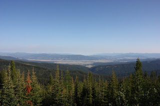
I stopped to rest just before crossing into Idaho and was confronted by a swarm of hungry rodents! I tossed them some bits of my lunch (radishes and crackers) and found that they were brave enough to run up and grab these things from my hand, if offered. One fat creature bullied the others but then refused to take the radishes; the others were not so picky. I stopped again briefly to take a photo of the Idaho mountains. The highway took me past Coeur d'Alene; I was satisfied just passing through. I then began descending into eastern Washington. That was to be another surprise…